The 2010-2011 La Niña was one of the
strongest in recorded history. Though the La Niña was officially pronounced
dead in April this year, this blog however had been predicting a multi-year La
Niña with a short intervening period of ENSO neutral conditions during
the boreal (northern hemisphere) summer. This was the basis of a pattern thrown
up by the analysis of its historical data.
There are preliminary indications that the
2010-2011 La Niña will be no different and most likely will take on a
multi-year character. The recent ENSO wrap up data of Bureau of Meteorology
(BoM), Australia for instance shows the Southern Oscillation Index (SoI) in
clear La Niña territory at +9.9 after a very brief period in neutral territory.
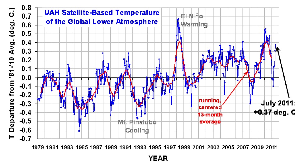
Global temperature anomalies as seen in the
above graph have slightly increased to + 0.375 C for month ending July 2011.
This should be the peak for this year and henceforth, global temperatures can
be expected to start plunging again.
Further, Stewart Franks, associate professor
in environmental engineering at NSW's University of Newcastle, said his
research suggested "enhanced" La Niñas for the next couple of decades at
the very least.
"What we noticed is El Niño and La Niña events are actually not
random, they tend to cluster, and they cluster on time frames between 10 to 40
years," he said.
Professor Franks, an Australian national
representative to the International Association of Hydrological Sciences, said
the last run of strong La Niñas occurred between the mid-1940s and mid-1970s,
culminating in the 1974 floods. They were followed by about three decades
dominated by El Niño dry climate patterns.
"We are seeing a return to the devastating impact of the enhanced
La Niñas we saw in 1945 to 1975, so that indicates to my mind that it's
entirely possible that were facing 20 to 30 years of repeated, frequent or
enhanced La Niñas," he said.
India: Monsoon & La
Nina
The "demise" of the La Nina is the
primary reason why the IMD forecasted India's seasonal monsoon to be
'below normal' in August and September. "Quantitatively, rainfall for the country as a
whole during the period August to September is likely to be 90% of Long Period
Average (LPA)," the India Meteorological Department (IMD)
said in its outlook for the second half of the monsoon session.
The annual rain season began on a good note with June receiving 111% falls,
followed by a slump in July which witnessed 86% rains.
While the weather office sees 46% probability
of below normal (86-94% of LPA) rainfall in the next two months, the
probability of deficient rains (less than 85% of LPA) is 27%. The country has
received 95% rainfall of the LPA in June-July. IMD said that the model error of
8% for August-September forecast would mean that some areas may get 98% rain
while it may be 82% in other places.
The re-emergence of the La Nina if any could mean that the NE Monsoon in all
probability could be above average and to that extent offset some of the
deficiency of the SW Monsoon.
But there is still a good chance of normal
rains during August-September. The Tokyo-based Regional Institute for Global
Change (RIGC) have maintained their forecast for the return of La Nina
conditions towards the autumn. The Climate Prediction Centre of the US National
Weather Services too had come out with an outlook recently suggesting the
return of La Nina later this year.
In what is a good sign for the Indian
monsoon, the RIGC has also said that the La Nina would be accompanied by a
‘weak positive Indian Ocean Dipole’ from August to November.
The India Ocean Dipole (IOD) is a seesawing
of ocean water temperatures in west and Indian Ocean, closely resembling the El
Nino-La Nina phenomenon in the equatorial Pacific but with more direct and
immediate impact on Indian monsoon.


No comments:
Post a Comment