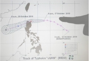
Typhoon Megi (catfish in Korean) a
category 5 super typhoon, the highest rating, with winds of more than 250 kph
(155 mph) slammed into Isabela province, northern Philippines at 11:25
a.m. It was last known heading southwest across the north of the main
island of Luzon. Megi, known as Juan locally, is the world's strongest tropical
cyclone of the year so far, according to website Accuweather.com.
The typhoon's eye had shrank to about 50 km
but is expected to bring more rain and stronger winds. However, it is expected
to weaken and slow down further after slamming into the mountains. The typhoon
at the moment remains a serious threat to lives and properties, as it still
packs maximum winds of 180 kilometers per hour (kph) near the center and
gustiness of 215 kph.
As it crashed ashore, the typhoon whipped up huge waves and toppled electricity
poles, cutting off power, phone and Internet services in many areas. There was
zero visibility and radio reports said the wind was so powerful that people
could not take more than a step at a time.
More than 3,000 people in coastal areas moved
to school buildings and town halls that were turned into evacuation centers though
initial reports confirmed 1 dead, a day after the figure was put as 10.
Cagayan valley accounted for 12 per cent of
national rice output, putting the region's rice crop at risk. Megi hit during
the region's peak harvest season, with more than 230,000 hectares of rice
fields still in their reproductive and maturing stages. An estimated 75%
of this capacity is assumed destroyed. This comes after Indonesia, the world's
third largest rice producer, announced that they will import up to 300,000
metric tonnes of rice in the country's first bulk purchase since 2007. Global
rice prices are accordingly expected to move northward.
Update: Latest
estimates of damage to rice is much lower - 1%.
Due to the La Nina, cyclonic activity is on a
high. During the SW Monsoon period, India has so far experienced 14 low
pressure areas - 13 over the Bay of Bengal and one over the Arabian Sea. We are
lucky so far. Last Friday, BoB 3 made a landfall though fortunately weakened,
without creating much damaged. But another low pressure area has developed
since.

No comments:
Post a Comment