
A strong western disturbance over the western
Himalayan region caused cloudiness over northwest and adjoining central India.
If snowfall played truant in Himachal Pradesh on Christmas and New Year's Eve,
then it made up for the lapse with a vengeance. Snow walloped Shimla, Kufri ,
Narkanda , Chail , Manali , Chamba and Dalhousie.
In fact the entire tribal belt of Kinnaur,
Lahaul and Spiti, Kullu and Chamba districts witnessed heavy snowfall. Shahpur
and parts of Hamirpur among other places also experienced snowfall and sleet
after a gap of more than three decades. And it's snowing in 'Queen of Hills' Shimla as well. This
after 8 years! The minimum temperature recorded in the hill station fell to
minus 0.8 degree C.
Dharamsala received snow after a gap of 35
long years. Located at a height of only 1,350 metre and the abode of Tibetan
Buddhist spiritual leader the Dalai Lama, Dharamsala was totally covered in
white, making the town more picturesque. In fact the snowfall was unusually
heavy with McLeodganj, its tiny hamlet, known for its strong British heritage,
receiving some of the heaviest snowfall on record.
Even Nurpur experienced snow. This after 45
years. But what really took weather forecasters by surprise was heavy snow
lower down in Kangra town. This was after a gap of a whopping 67 years! The
peculiarity of Kangra, Nupur and Dharmasala are that these are foothills where
snowfall is not normally expected because of their low elevation. But Himachal
Pradesh is not complaining. Good amount of snowfall has not only rejuvenated
its glaciers, but also proved beneficial for its tourism industry, with scores
of tourists making a beeline to the hill state. Hotel accommodation and
flights are reportedly fully booked.
It gets even better. Probably for the first
time in the recorded history of Punjab, several villages of Pathankot and
Hoshiarpur districts experienced snowfall on Saturday morning. The two
districts normally experience maximum temperature of up to 45 degrees Celsius
in summer. The Met office however dismissed the event as a 'freak' happening due to change in
wind directions.
Last Friday, parts of New Delhi and Amritsar
woke up to be greeted by a hailstorm. It is not that hailstorms are a
rarity in these parts of the country. It usually takes place during the
transition period where winter gives way to spring. This is when temperature
rises initially in the southern parts of India, giving rise to thunderstorms
and squally weather, including hailstorms in Northern India. The problem is
that we are not in this transition period and in fact only now entering into
the peak winter season.
So what could have triggered the hailstorms?
My friend, Rajesh Kapadia who administers the blog Vagaries of the Weather explain
that conditions for snow are a) surface temperatures are below freezing upto 2
deg C b) atmospheric temperatures are below freezing c) air
contains a minimum moisture level. Atmospheric temperatures were below
freezing but conditions of surface temperature and minimum moisture levels for
snowfall were not meet to create snow and so the western disturbance impact on
New Delhi and Amritsar probably took the shape of hailstorms. This of course
remains a logical conjecture.

Meanwhile, more than 3 feet snow received
over the past two days closed down Kashmir's main highway, stranding hundreds
of travellers. The snowfall on either side of the Jawahar tunnel, blocked the
only road link, connecting Kashmir to rest of the country, and traffic has been
suspended. Trucks carrying supplies to Kashmir haven't moved a bit in the past
three days because the Jammu-Srinagar highway that connects the Valley with the
rest of India is closed due to heavy snowfall and landslides.
The heavy snowfall also knocked out power and
telephone lines after the 220 KV-Kishanpur-Pampore and 400 KV Kishanpur-Wagoora
transmission lines snapped on other side of Jawhar Tunnel due to
snowfall. Against the required 950 MW of electric power being supplied to
the valley, the availability this time is pegged at 120-150 MW. Among the
available power, 40-50 MW is being supplied to consumers while rest is being
used for running essential services. The plight of residents made worse as
J&K is already facing shortage of fuel- LPG and kerosene- for cooking and
heating purposes.
Temperatures at Srinagar plummeted to minus
5.5 degree C, the coldest night in the city this winter. Due to the extreme
cold, water taps in most areas of Srinagar were frozen in the morning.
Picturesque tourist spot Gulmarg recorded a low of minus 16.5 degree C.
Qazigund’s low dipped to minus 8.4 degree C followed by Kokernag (minus 6.3 degree
C), Pahalgam (minus six degree C) and Kupwara (minus 5.6 degree C).
The Dal Lake was frozen at many places too.
Kulgam town in south Kashmir received 2 feet of snow while Srinagar,
around 5 inches of snowfall since last evening. High-altitude areas including
the ski resort of Kupwara district which recorded night temperature of minus
0.3 degrees Celsius, had 14.4mm of fresh snow till early morning.
Pahalgam, received fresh snow of 8cms during
the time while the world famous hill resort in south Kashmir, recorded a low of
minus 1.8 degree C. Kargil district in Ladakh witnessed the first heavy
snowfall of the season with Kargil town recording 2 inches of snow while Drass
had about 3.5 inches on the ground this morning. Taisuru and Rangdum also
recorded 2 inches snowfall. In Leh, temperatures plunged to minus 18.8 deg C.
India is experiencing a harsh winter
characteristic of a La Niña winter. So how does rest of the world shape up this
winter?
GLOBAL WINTER
Let’s look at the latest satellite temperature
imagery for today.
From these temperature maps it is evident
that most of the extreme cold is confined to Canada, Russia and Northern China.
Winter by and large had been mild in most other areas within the Northern
Hemisphere. So mild that huge swathes of Northern India are currently colder or
at comparable temperature to much of Western Europe.
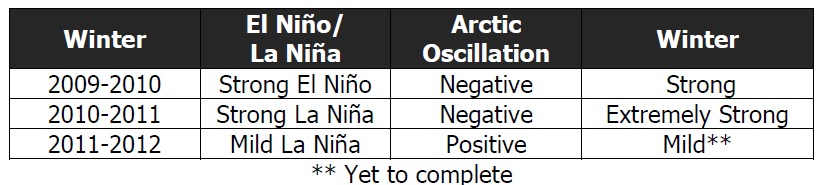
The table illustrates that El Niño-Southern
Oscillation (ENSO) by itself is not sufficient conditions to determine the
character of winters within the Northern Hemisphere. More important is the
Arctic Oscillation (AO) Index. The erratic AO can generate strong shifts in the
climate patterns that could overwhelm or amplify La Niña's or El Niño’s typical
impacts.
Technically, the Arctic Oscillation is a
measure of atmospheric pressure variations at sea level north of 20N latitude.
Whenever an Arctic high or low develops, it affects weather thousands of miles
away.
Last year the so-called "Arctic fence" that keeps
cold air penned up in the north broke down, allowing frigid air to spill south.
So far that's not happening this winter which should explain the mild winter at
the mid latitudes. However, the AO is a fickle—not seasonal—phenomenon and can
switch erratically between the two modes.

As seen in the NOAA graph, the AO has been in
its positive phase for the last 4 months, being particularly very strong all
through December and first week January this year. The exception was a couple
of days around the middle of October and before Christmas when it briefly
flipped to its weakly negative mode. But each time it showed a strong streak of
resilience - rebounding quickly to its strongly positive mode again.
But yesterday, it flipped back to its weakly
negative mode again as that Northern India and Pakistan received a snow packing
wallop. At the same time, in Europe, Austria found itself buried under 4
feet of snow, creating chaos and disruption of traffic and power supply.
Snowfall trapped some 15,000 tourists at ski resorts on the Arlberg Mountain on
Friday, and while some roads are open there, others remain closed. High winds
are also whipping the nation, and closed an important rail line. Most snow has
fallen in the western states of Tyrol and Vorarlberg. 52 people were
rescued by an army helicopter there. An important rail line that connects Vienna
and Innsbruck with western Austria and Switzerland was to be closed until
Sunday. Two rail lines that connect western Austria with Germany were also
closed.
These two events may look unconnected but
they need not. They occurred the same time as the AO flipped to it weakly
negative mode. But the moot question is whether a negative AO is just a
blip or something longer in duration?
So what do weather ensemble models indicate?
As seen in the above graph, some show the AO index rebounding and going
positive while others (the majority) have it trending negative and ending below
zero.
Two weathermen think on similar lines. On
Twitter, former Accuweather and now with WeatherBell, legendary weatherman Joe
Bastardi observed:
“10mb [stratospheric] warming on European [model] over the pole by 360
hrs reaches 50C!!!! This is a huge event and will have [northern] hemisphere
cold implications…By that I mean, something major is about to happen.”
Henry Margusity Accuweather also anticipating
a major change similarly observed:
“This is such an amazing weather pattern evolving.
I told all the [meteorologists] that we have a lot of winter ahead of us.”
It was left to Dave Tolleris of Wxrisk to
make a more nuanced statement about a possible pattern change. He stated:
“All
this being said this does NOT mean the winter of 2011-12 is about to turn nasty
for everyone and or the Northeast is going to see big snows or noreasters. …It
might turn that way but we don’t know that yet. But the old winter pattern of
2011-12 that has featured sustained warm/ mild dry pattern is going to end
soon. And whatever the new pattern … won’t be the same as what the last 45-60
days have been.”
“Much of the excitement by Bastardi and Margusity probably stems from a
strong stratospheric warming event that is now showing up on the model guidance
and how it might lead to more blocking and a negative Arctic Oscillation (AO).
Remember, a negative AO means a cold and sometimes snowy weather pattern over
the eastern U.S...
The pattern change ideas stem from research by Baldwin and Dunkerton
published in a 2001 “Science”
article which documents how there is coupling between the
stratosphere and troposphere and that sudden stratospheric warming events can
have an impact on the AO (by helping modulate the strength of the polar
vortex), flipping it negative...
That research notes that once the warming propagates down sufficiently
to produce a weather pattern favouring a negative AO (lots of high latitude
blocking), the pattern tends to last for about two months. That probably
explains why some forecasters think that if the AO goes negative it might stay
that way through much of the remainder or the winter....
The potent polar vortex event and positive AO that has been going on
for over two months already appears to be on the wane with or without help from
the stratosphere. This strong vortex event has lasted longer than most such
events so the forecasts of it weakening may have some merit.”
What all this means is that a big pattern
change in winter outlook is due in the next 7-14 days and the odds favour
a strong negative AO. If Europeans and Northern Americans have put away their
woollies and not stocked up on their heating oil, then it is time they did so
in a hurry as a harsh winter is speeding their way and when it does will
probably not go away for the next 2-3 months.
In India, if you thought that winter would
have peaked by month end, you could be likely to be wrong. Instead, the
cold wave could turn even harsher. Much of the cold wave and snow in the
country is linked to what called western disturbance (WD), which is a term used
in India, Pakistan, Bangladesh and Nepal to describe an extra-tropical storm,
originating in the Mediterranean that brings sudden winter rain and snow to the
northwestern parts of the Indian subcontinent.
This is a non-monsoonal precipitation pattern
driven by the Westerlies. The moisture in these storms usually originates over
the Mediterranean Sea and the Atlantic Ocean. Extra-tropical storms are a
global, rather than a localized, phenomena with moisture usually carried in the
upper atmosphere (unlike tropical storms where it is carried in the lower
atmosphere). Once their passage is hindered by the Himalayas, they are unable
to proceed further, and they release significant precipitation over the
southern Himalayas. In winter it brings snow and sleet.
As a strong negative AO brings cooling to the
Mediterranean Sea and the Atlantic Ocean, this in turn creates stronger WDs
that in turn create higher likelihood of snow, sleet and plunging temperatures.
Then again, the AO is so unpredictable and
could prove everyone wrong.
It gets even better. Probably for the first
time in the recorded history of Punjab, several villages of Pathankot and
Hoshiarpur districts experienced snowfall on Saturday morning. The two
districts normally experience maximum temperature of up to 45 degrees Celsius
in summer. The Met office however dismissed the event as a 'freak' happening due to change in
wind directions.


This place is the best to stay while spending holiday seasons.
ReplyDeleteTel Aviv Events Should Never Be Missed Out