
Despite being well known that no two events are exactly alike; there had been increasing speculation in both the media and by international climate agencies of a ‘Super’ El Niño à la 1997-98 striking this year, which in turn is expected to adversely affect the South West Monsoon (SWM) rainfall and agricultural production in the country.
Geez – a ‘Super’ El Niño??? It’s a bad enough that seasoned meteorologists have to struggle each year even to predict the emergence an El Niño with great degree of certainity. But here are crackpots actually prepared to wager bets on its intensity and worse still, even more cranks in the world including the gullible sections of the media willing to swallow their hype without question!!
Historically, the odds are stacked heavily against a ‘Super’ El Niño developing this year. The last two events were in 1997/1998, and 1982. Both these events occurred during the positive or warm phase of the Pacific Decadal Oscillation (PDO). During the cool or negative phase of the PDO (which we are currently in), overall the El Niño events are less frequent and of lower magnitude. The strongest El Niño in a previous cool phase of the PDO was in 1972/1973, at the fag stage of the last cool PDO cycle. Of these three, the 1997/98 event is widely considered having the greatest intensity on global temperatures with the 1972/73 the least impact. The real intensity of the 1982 event on global temperatures has not been fully established being offset by some measure or otherby the global cooling triggered from El Chichon volcanic eruption.
But since nothing is impossible and if by chance we were to witness a repetition of 1997-98 this year, we should actually have absolutely nothing to worry about. Even the new Modi Government in the country could even actually afford a huge sigh of relief. Why? Because the total rainfall for (June-Sept) 1998 was 943.1 mm or + 4% above the Long Period Average (LPA) according to the Indian Meteorological Department’s (IMD) data. Compare this to 1972 (when the PDO was negative as currently is) when rainfall deficiency was a whopping 24% or 13.5% in 1982 (when the PDO was in its positive mode)!!! So if I were highly image conscious Narendra Modi, desperate to be seen to deliver results fast, I would get down on my knees and pray feverishly for a repetition of 1997-98 and not for either the 1972-73 or 1982 event!!
The fact is that till mid-May, no international model has predicted a Super El Nino as seen below:

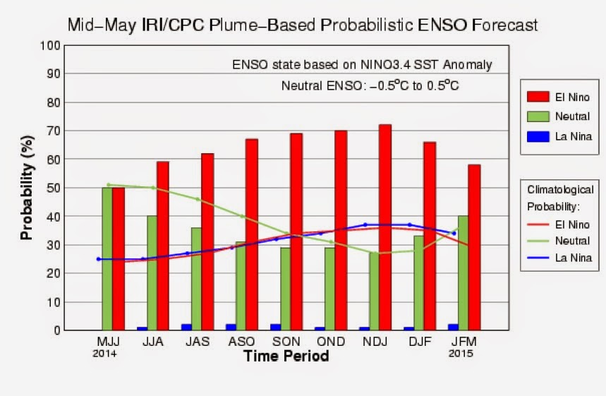
Meanwhile, this is what the Indian Meteorological Department (IMD), the country’s official weather forecaster and SkyMet the supposedly country’s leading private sector meteorologist, had to forecast for this year:

Both these forecasts are in tandem with those of the Australian Bureau of Meteorology, the US Climate Prediction Centre and South Asian Climate Outlook Forum affiliated to the World Meteorological Organisation.
However, there are already strong signals that the 94-95% of LPA rainfall forecast could be totally off the mark and instead the country is plunging into one of the worst droughts in recent times.
Generally, the monsoon comes to Kerala by June 1, after which it goes northwards up to central India by June 12. This year, the IMD informs us through an update that the southwest monsoon is not expected to reach Kerala before June 5. A scientist from Indian Institute of Tropical Meteorology (IITM) had this to observe to Times of India:"The forecast does not paint a rosy picture. If the monsoon is delayed or is not as strong as it was during 'normal' years, the first spell of rainfall may be insufficient and possibly will not suffice farmers' sowing needs...
A low pressure system usually forms over the Bay of Bengal around the last week of May. Simultaneously, a low pressure system also forms over the Arabian Sea, which causes the monsoon onset over Kerala. However, this time, the low pressure system over Arabian Sea seems to be absent, which in turn will slacken the strengthening and progression of the monsoon."Translated - the presence of a low-level anticyclone over central India and the absence of easterlies over northern parts of India are expected to also seriously hamper the northward progression of monsoon at least till June 15, thus causing delayed monsoon advancement over the country. Accordingly, the delayed timing of mid-latitude systems deeply penetrating into northern parts of India could be expected to also have an adverse bearing on monsoon advancement over the country.Within this context, this blog provides a counter forecast to the ones published by both IMD and SkyMet. In the last two years, our forecast hit the bullseye and we hope this year we register a hattrick though we realize it is often very difficult to be third time lucky. This is specially so as forecasting rainfall is proving particularly challenging due to greater degree uncertainties prevailing this year.Those interested can read our archive which was re-published in a few mass media who we contribute occasional articles on climate and weather. Read here - Monsoon Forecast: Give the Met Dept a break. They are still on target and so are we!The IMD forecast was based on five factors: the Sea Surface Temperature (SST) gradient between north Atlantic and north pacific, equatorial South Indian Ocean SST, East Asia mean sea level pressure, northwest Europe land surface air temperature and equatorial pacific warm water volume. Skymet on the other hand did not adequately disclose on what parameters their forecast model based itself to arrive at their forecast. As for our forecast, we considered just two parameters El Niño -Southern Oscillation (ENSO) and the Indian Ocean Dipole (IOD).The only other change this year is unlike the previous two years, we experimenting with a totally experimental forecast method which we are pilot testing this year.
ENSOAccording to Bureau of Meteorology (BoM), Australia the following is the latest Niño region SST departures:

As seen from the latest SST anomalies, Nino3.4 is still just a tad short of crossing El Niño threshold values. The fact remains that the equatorial cross-section of the Pacific is no way near the strength of the early stages of the 1997-98 super-El Niño. The eastern Pacific is much cooler overall than it was 1997-98 though it gained back some heat lost in recent weeks.Legendary weatherman, Joe Bastardi of WeatherBell Analytics offers a forecast through his tweet“This warm event is reactionary to the cool previous 3-4 yrs, and will self destruct after 9 months, much like 50s-70s”The UK Met Office’s model projections also appear to be very cool to the media hysteria of Super El Niño as seen below:

The International Research Institute for Climate & Society (IRI) forecast too appears totally pessimistic of the prospects of a Super El Nino this year as seen from their model forecast below:
In 2012, an El Niño developed but mysteriously fizzled out - a first time in recorded history. So would the Niño 2014 fizzle out too after showing some promise? We would be inclined to think in the negative. When a +0.5 deg C Niño3.4 meets 1.3 deg C Niño1+2 on one hand and with a 0.7 deg C Niño4 on the other hand, through diffusion of oceanic temperatures the tenuous candle flicker can easily burst out into a raging flame. Accordingly, on the basis of current data, the chances of El Niño fizzling out do look very bleak and the 70% probability for one emerging this season looks prima facie justified.However, from looks of the same data, it appears very unlikely that the warm stream of the Central Pacific would reach all the way to the Pacific shores as it did in 1997-98 precisely for the same reasons. With huge temperature difference between Nino4; Nino3 and Nino3.4 regions, diffusion of heat processes will probably facilitate as its biggest stumbling block to do so.In the NINO1+2 region, temperature anomalies have broken away sharply from the 1982/83 El Niño evolution, but they’re currently still far below the values for 1997/98 El Niño though they have rebounded somewhat smartly in the last few weeks. We’ll have to keep an eye on the NINO1+2 data, because they’re an indicator of a Central Pacific El Niño commonly known as El Niño Modoki which looks increasingly likely from the SST map below.

The warm SST anomalies are seen over the equatorial central Pacific is expected to gradually intensify and peak in the central Pacific by Oct-Nov-Dec this year and then decline. But just take a look again at Niño1+2 from where it could be observed that the warmest anomaly had been centred within the western portion of the ENSO monitoring area. Heat is obviously still transferring westwards - a fact validated through the latest SST departures. This unique warming in the central equatorial Pacific associated is flanked by a colder sea surface temperature anomaly (SSTA) on both sides along the equator as again seen in the map.

According to BoM, Australia, the Southern Oscillation Index (SOI) has remained within neutral values, with a positive bias over the past two weeks. The latest approximate 30-day SOI value to 18 May is +3.0 deg C, still below Nino threshold values.

However, SOI is expected to revert to its negative mode and cross El Niño threshold values in the coming weeks. Joe Bastardi of WeatherBell however tweets a cavaet:“Vast difference SST nr Australia vs Super Niño year. Warm SST this yr means lower pressure there inhibits SOI coupling....”Poorer prospects of coupling between SOI and SSTs in the Central Pacific could act as yet another major constraining factor for the emergence of a ‘Super’, if not a strong El Niño this year.

As seen from NOAA’s graph plots, while there is some progression towards basin wide El Niño, the (0-300 m) upper-ocean heat anomalies (positive) and thermocline slope index (negative) values again do not yet match 1997-98 to justify all the hype of a ‘Super’, leave alone a strong El Niño being on its way!
Sub-surface temperatures in the Niño region has in fact significantly decreased in April and only very partially succeeded during May in gaining ground lost. Weather specialist Rusy Abastillas of Pagasa’s Climate Monitoring and Prediction Centre in the Philippines observed:“But right now, the probability has slightly decreased, so we’re adjusting our prediction to June, July or August. Pagasa made the adjustment after noting the slow warming of the Niño 3.4 region and we observed that it’s taking some time to hit the threshold level of 0.5 degree Celsius. It’s ranging from 0.2 to 0.4 degrees.”Enhanced oceanic Kelvin wave activity has been observed since early August 2013. Such wave activities are widely considered a precursor to the formation of an El Niño event. In late January 2014, the downwelling phase of a strong Kelvin wave was initiated. The weakening of the positive temperature anomalies seen during April represented the abatement of the upwelling phase of the Kelvin wave in the Eastern Pacific which in turn is expected to lead to progressive strengthening of positive temperature anomalies hereafter.As a result, currently, the Trade Winds have not dropped off as far as they did at this point in the development of the 1997-98 Super-El Niño. This is inspite of them being observed to be relatively slowing down. It is to be further noted that trade winds which normally blow east to west has to weaken to allow the warm water that's pooled up in the west to start spreading eastward.

However, the NASA/French Space Agency Jason-2 satellite maps all the world’s oceans, has spotted something which they claim as brewing in the Pacific which they further claim looks a lot like the 1997 event. Bill Patzert, a climatologist at NASA’s Jet Propulsion Laboratory observed:“A pattern of sea surface heights and temperatures has formed that reminds me of the way the Pacific looked in the spring of 1997. That turned out to be the precursor of a big El Niño.”What Jason-2 has been seeing is a series of “Kelvin waves“—massive ripples in sea level that travel across the Pacific from Australia to South America. The two phenomena, Kelvin waves and El Niño, are linked by wind. Pacific trade winds blow from east to west, pushing solar-warmed surface waters toward Indonesia. As a result, the sea level near Indonesia is normally 45 cm higher than it is near Ecuador. Researchers call that area the “warm pool”—it is the largest reservoir of warm water on our planet.Sometimes, however, trade winds falter for a few days or weeks, and some of that excess sea level ripples back toward the Americas. Observes McPhaden:“That’s a Kelvin wave. It’s not unusual to see a couple every winter.”For an El Niño to happen, then trade winds need to falter for many months in a stretch. Then Kelvin waves crosses the Pacific like a caravan, raising sea level and leaving warmer equatorial waters in their wake. Patzert recalls:“The El Niño of 1997/98 was a textbook example. Sea surface maps showed a whitish bump, indicating a sea level some 10 centimetres higher than usual, moving along the equator from Australia to South America.”But at some point there would be too much warm water piling up and an El Niño gets triggered. The trade winds at this point usually weaken or even reverse entirely, moving warm water eastward. As it travels, this warm water starts emerging from deep in the ocean and heating up the atmosphere. These are the conditions that scientists claim are seeing right now. Moreover, the blob of warm water in the east is unusually large this year, leading many researchers to predict a monstrous El Niño is on its way.The expectation of the section of scientists (those hyping a 2014 Super El Niño) is that such a threshold had been indeed reached with the weakening of the positive temperature anomalies seen during April. Mike McPhaden of NOAA’s Pacific Environmental Research Laboratories in Seattle observes:“The same pattern is repeating in 2014. A series of Kelvin waves generated by localized west wind bursts in the western Pacific that began in mid-January 2014 are headed east. Excitement is building as a third weakening of the Pacific trade winds happened in mid-April.....However, he adds a caution:“We can’t yet say for sure that an El Niño will develop in 2014, or how big it might be but the Jason-2 data leads to alot of speculation....It will become much clearer over the next two to three months whether these recent developments are the forerunner of a major El Niño—or any El Niño at all.”This caution can be captured by the Nino region SSTs till April 30 this year – which clearly illustrates how weak the expected current year’s event could be as compared to 1997-88:

It was left to meteorologist Michael Ventrice of Weather Services International to hit the hammer on the head of the other nail:
“The main question right now is if this entire warm-pool region will accelerate to the eastern basin or stick in the middle of the Pacific.”If the warm water decides to stick around at the International Date Line or so, we will get what is called an El Niño Modoki. Cold water would remain in the eastern Pacific during El Niño Modoki. Should the warm pool make it all the way to the South American coast, a much stronger “full-basin” El Niño will appear. And then we could be in for some big weather changes. Even so, the winter is when El Niño really gets going, though.

If we look again at OISST Anomaly map given earlier in this post and compare them with the above illustrative SST maps differentiating an El Niño and a Modoki, on the basis of its current evolution, it looks more like evolving into a Modoki rather than a canonical event. Don’t miss the huge stream of cooler waters near coast of Peru.... and that should keep Nino1+2 temperatures in check, if not cool it down rapidly...Similarly the cold streams North-west of Australia and North Pacific should keep Nino4 and Nino3.4 SSTs in check... So SSTs with the Nino region, at least during the monsoon months June-September, looks highly unlikely to show any runaway increases, at least on the basis of current data.
From all these discussions, what we can conclude on the basis of current data is that it looks still extremely uncertain whether an El Niño would develop at all, leaving aside if it could adversely affect monsoon rains. However the probability remains very high. Even if one develops, its effect would be most likely felt more intensely during the 2015 monsoon season rather than the current year. As for this year, what’s most probable to expect is a somewhat weak to moderate episode coming into effect during the second half of the monsoon season. A more fundamental question - whether the episode could be one of a canonical or Modoki variety remains unanswered - though the odds favour a Modoki event.Given these large uncertainties, this forecast has made the following assumptions:a. Nino3.4 and SOI reaches threshold value by May end/first week June, if sustained for 3 months, facilitating confirmation of an El Niño episode earliest by end of August
b. Monsoon months June-September Nino3.4 demonstrates only weak to moderate intensity. The maximum intensity of an El Niño is usually felt 5 months post the event. This means, prospects of rainfall for the 2015 monsoon season could on all likelihood be much worse than for the current year.
c. Rather than a canonical Niño as in 1997-98, the chances of a Modoki are much higher this time round. [It is to be noted that data reveals the frequency of Central Pacific El Niño or Modoki is much higher than those of a canonical or East Pacific El Niño]Indian Ocean Dipole (IOD)

According to BoM, Australia, the IOD remains neutral, with the latest weekly index value (18 May) at zero (-0.09 °C). Past data has indicated that the probability of a positive IOD event tends to be elevated during an El Niño viz. positive IOD events tend to coincide with El Niño episode.Accordingly, while we forecast an IOD turning progressively positive, we nevertheless expect the IOD to remain in neutral region for most part of the monsoon months June-September. We do not expect the IOD to cross +0.4°C earlier than mid August.
However, as compared to a canonical El Niño, Modoki events are less likely to show strong teleconnectivity with IOD. In other words, for 2014, we expect ENSO as more likely to trump IOD than vice versa.
Forecast: South West Monsoon 2014MARGIN OF ERROR:+/-5%ENSO:
Weak to moderate El Niño Modoki Category 1The BoM Australian model latest forecast for Nino3.4 is given below:

Six of the seven internationals models suggest that El Niño thresholds may be exceeded as early as July. We on the other hand expect El Niño thresholds to be crossed much earlier - by end of May or by beginning of June.The BoM forecast indicates a weak El Niño. We on the other hand forecast a weak to moderate strength El Niño as detailed below:

IOD FORECAST:
IOD is likely to remain neutral through late autumn and early winter, with two of the five international models suggesting that a positive IOD may develop by early spring. However, model prediction of IOD is far from a precise science. IOD is known to change its mode quite rapidly and at times erratically.According to JAMSTEC, Japan, the primary IOD trend is negative which is unfavourable to the monsoon. If at all most model projections indicate that IOD values will stay within the neutral zone albeit a positive bias all through JJAS (the monsoon months), this can be treated merely as sort of a reflex response to either the boreal summer or El Niño effects and hence temporary. In any case we expect this year that ENSO will trump IOD as opposed to 2012 wherein it was the other way around.In our model we have accordingly factored the IOD to be mostly within the neutral range during the monsoon months, progressively increasing in positive values with expectation that it would equal or exceed +0.4 C deg by August.

FORECAST: INDIA JUNE-SEPT RAINFALL

Accordingly, we forecast the June-Sept rainfall for 2014 SWM would be around 84% of LPA or with a 16% deficiency +/- 5%.
“When the rainfall for the monsoon season of June to September for the country as a whole is within 10% of its long period average, it is categorised as a normal monsoon. When the monsoon rainfall deficiency exceeds 10%, it is categorised as an all-India drought year.”On the basis of the above government definition, if this forecast is realized, this would make 2014 an all-India drought year, and probably the worst for this century.
REGIONAL JUNE-SEPT RAINFALL

Accordingly, the Southern and North-Western regions would bear most of the rainfall deficiency while North-Eastern regions expected to come out almost unscathed.
IMPLICATIONS
If this forecast materializes then the new Modi government would be facing a huge crisis this year as the country would face massive and widespread drinking water and power scarcities; sharp reduction in crop yields, increase in crop failures and farmer suicides accompanied by food shortages and food inflation. Having announced their intention to cut the fiscal deficit, the cost of mitigating these problems could easily negate the former objectives of the Modi government.
The good news however that is an El Niño though adversely affecting the kharif crop has a very positive impact on rabi crop. We can expect above average to excess rainfall during the rabi season leading to floods in many of the usual suspect places. Some of the shortfall in agricultural commodities could be attempted to be made good during rabi. The flop-side is that a warmer than average winter temperatures would adversely affect crops like wheat, whose output is expected to take a huge hit.
We should see higher than normal, if not elevated cyclonic activity on the Arabian Sea side of our coastline post monsoon season. If any in the Arabian Sea makes landfall, then the task of relief and rehabilitation may add to the woes of the new government in managing the fiscal deficit.
Assuming an El Niño develops, we are inclined to believe that it would be most likely of short duration – viz around 9 months as seen during the 50s and 60s. But there are expectations from scientific circles, particularly from the climate hysteria groupies, such an event may drag on for 12-18 months. In either case, we would be poised for a back-to-back drought with 2015 monsoon season proving even worse than 2014 in terms of rainfall deficiency.

As El Niño effects are already pronounced around the world, including India, climate alarmists are having a field day spewing out hysteria. After the 1997/98 El Niño, climate alarmists started extrapolated global temperatures increasing them up to 5 deg C and beyond by 2100. Instead, what they got was over a 15 year global temperature pause or hiatus as they prefer to describe the phenomenon. From then on, each year they had been consistently praying for a ‘Super’ El Niño which they further assume is adequate to break the hiatus and further trigger the global warming trend to resume their upward march, ensuring that their “climate alarmist” grants keep flowing.In 2012, these climate alarmists also predicted a ‘Super’ El Niño with great gusto, but what they got instead was Nino SSTs reaching threshold levels and mysteriously dissipating soon after. In fact if at all we had hit the bullseye in our monsoon prediction of 2012, this was we had anticipated such dissipation. We had then spotted a huge pool of very cold waters flowing from Alaska towards the Nino region which we further assumed as sufficient to dissipate the El Niño. When it turned out as we expected, this was the first time in recorded history when an El Niño went decisively past threshold levels and dissipated almost instanteously!So come 2014, the global climate alarmist brigade is back to the old hysteria game of generating hype of an impending ‘Super’ El Niño which they claim has far reaching catastrophic consequences the world has not seen before. Here’s a sampler:“Should the rest of the Kelvin wave follow, temperature anomalies in this region will spike well above 4 C and possibly has high as 5-6 C. Such an event would be even stronger than the one seen in 1997-98, drive global temperatures about .05 to .2 C hotter than previous records in a single year, and set off a series of extreme weather that, when combined with the already severe conditions set in place by human-caused warming, may well be far in excess of those seen during past events.”These extracts are by one Robert Scribbler from his article Monster El Nino Emerging From the Depths: Nose of Massive Kelvin Wave Breaks Surface in Eastern Pacific which was hyped by many in the mainstream media. But just who is he to write with such authority? A well known climatologist? Not a chance. So we go to his page in Gravatar and this is how he describes his professional background:“I'm a progressive novelist, non-fiction writer and emerging threats expert. I've served 8 years in the combat arms, spent 3 years as a police officer, and spent 3 years as Editor, Emerging Threats for Jane's Information Group.”So he is basically a story teller and although he positions himself as a non-fiction novelist, the extracts contradict him as what their contents point is that they are an embodiment of pure science fiction. Bob Tisdale tells us why?“Can an El Niño produce sea surface temperatures in excess of 5 deg C in the eastern equatorial Pacific? Yup. Would it be unprecedented? Nope. It happened during the peak of the 1997/98 El Niño, contradicting Robert’s speculation.”The moot question is whether 1997/98 could be repeated in 2014? Kevin Trenberth is a prominent IPCC climatologist and a true-blue proponent of the hypothesis of human-induced global warming. For about a year, he has been promoting the “big jumps” in global surface temperatures, with the steps in the staircase of global surface temperatures being caused by El Niño events. It is interesting what Trenberth said in a recent New York Times on the global temperature hiatus:“Climate scientists don’t fully understand the exact mechanics of this phenomenon. But the suspicion is certainly that it is related to El Niño events...The switch to the current negative phase was probably triggered by the 97-98 El Niño....The question is whether this fall’s El Niño “might kick the PDO into a positive phase...If it does, a result would be faster warming, at least doubling the rate of surface temperature increases.”
Forget that part of Trenberth clutching at straws of a “Super” El Niño triggering a process where the global temperature hiatus is broken unleashing unbridled global warming again. Perhaps for the first time climate alarmists have clearly admitted to the role of ENSO and PDO in regulating global temperatures. It is extremely interesting that he is of the opinion that“current negative phase was probably triggered by the 97-98 El Niño”Atmospheric heat is periodically accumulated and stored by the oceans through mechanisms like La Nina. Likewise the oceans also periodically get rid of the excess accumulated in its waters through mechanisms like the El Niño. So it is only logical to expect the burst of tremendous energy by the 97-98 El Niño to have left the oceans much cooler than before the event. This combined with the fact that the 97-98 event came at the last legs of the 25-30 year PDO cycle gives some weight to his opinion that it may have triggered the PDO turning negative. Below we can see how much the oceans have cooled remarkably between 1997 and present.

It is precisely because the PDO is in its negative mode that a strong El Niño, leave alone a ‘Super’ event is highly unlikely this year. There would be certainly a temporary global spike in temperatures but after every El Niño, trails a La Nina which would swamp such warming. So we can expect a La Nina most likely during the 2015-16 season. Though the current year’s winter should be warmer than normal, the one next season 2015-2016 should be one of the coldest for the century as the ocean temperature could be expected to drop further.
You have seen trailer in the last few years of the kind of winter round the globe. After this El Niño, whether weak, moderate, strong or ‘Super’, in 2015, get set for the main movie. Welcome to the Little Ice Age!
PLEASE SEND ME INDIA MONSOON UPDATES ON soloshaks@gmail.com particularly after EL-NINO
ReplyDelete